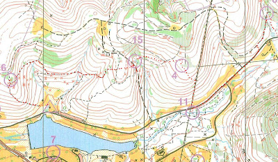
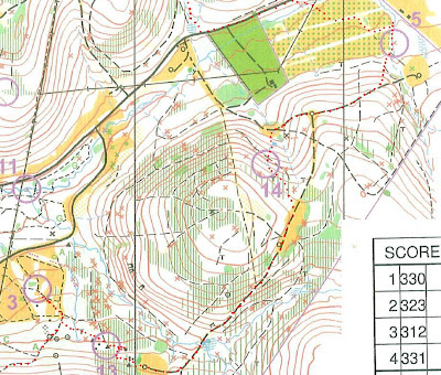
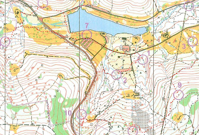
Control 4 was challening due to the lack of features, but got lucky, and saw the control even with the lush foliage. 11 was easy due to the powerline nearby. From 8 to the road, the lush and marshy vegetation was noteable. Across the pine tree forest on approach to 5 got lucky in finding my way, even recognized the non-pine tree thick vegetation in the middle of the pine forest. Approach to 14 was to the pond near the clearing, and from the pond, the control was very visible in the forest with very little vegetation. 13 was touch, due to some thick vegetation and lots of foliage. Recognized the two small boulders, then went W, circled around, found the big boulder and realized I had to go more West. Approach to 9 was very easy, simply followed the stream as handrail. To 16, it was difficult. Reconized the story ground, then the lack of stony ground, went NW to find again the stony ground, then the small streambed and eventually to the control, very cleaverly covered by the boulder when approaching from downstream. On approach to 10, got bit confused as I was going downhill, then went back uphill to find the big trail (could have continued downhill to trail below). On the control location, got tricked by following upstream, then returned downstream, saw the stream junction, and saw the control as being downstream from the junction. Heard cars, figured the road was nearby, ran to it, along it, then at bend, rolled downhill to trail to lead me to control 2. Approach to 1 there is another reentrant nearby and got a big tricked by that, figured that maybe this map doesn't show these small reentrants, so continued NE and found the stream, then upstream, then the control. Then to the road, incredibly did not realize control 7 was right on the way, continued to 12, got a bit tricked by the numerous parallel reentrants, but again, figured I was looking for a bigger one, streambed, and eventually saw the control going uphill on the stream side. On location of control 17, knob seems positioned very close to the corner of the clearing, but it is actually a good 25 meters. At the punch, realized 7 was missing, and corrected it by running to it and back, with almost 3 minutes to spare.
Monday, June 23, 2008
Orienteering at Blue Spruce Park, Indiana, PA
After the last control, realized that in the control card there was a blank square with no holes punched on it. Box number 7. Is there a control 7 ? I check on the clue sheet and see it is on the course. Wow !!! how did I miss it? I see it on the map, with just 5 minutes remaining to the 90 minute deadline, do I have time to get to it and back ? I think I do, and even if I come late, who cares... The incredible thing is that I ran right near it, about 20 meters from it, while a wedding group was posing for pictures right next to that silver pine tree. Must have not seen it on the map because all other control circles have a white background, but this one had a darker (open clearing) background.
Control 4 was challening due to the lack of features, but got lucky, and saw the control even with the lush foliage. 11 was easy due to the powerline nearby. From 8 to the road, the lush and marshy vegetation was noteable. Across the pine tree forest on approach to 5 got lucky in finding my way, even recognized the non-pine tree thick vegetation in the middle of the pine forest. Approach to 14 was to the pond near the clearing, and from the pond, the control was very visible in the forest with very little vegetation. 13 was touch, due to some thick vegetation and lots of foliage. Recognized the two small boulders, then went W, circled around, found the big boulder and realized I had to go more West. Approach to 9 was very easy, simply followed the stream as handrail. To 16, it was difficult. Reconized the story ground, then the lack of stony ground, went NW to find again the stony ground, then the small streambed and eventually to the control, very cleaverly covered by the boulder when approaching from downstream. On approach to 10, got bit confused as I was going downhill, then went back uphill to find the big trail (could have continued downhill to trail below). On the control location, got tricked by following upstream, then returned downstream, saw the stream junction, and saw the control as being downstream from the junction. Heard cars, figured the road was nearby, ran to it, along it, then at bend, rolled downhill to trail to lead me to control 2. Approach to 1 there is another reentrant nearby and got a big tricked by that, figured that maybe this map doesn't show these small reentrants, so continued NE and found the stream, then upstream, then the control. Then to the road, incredibly did not realize control 7 was right on the way, continued to 12, got a bit tricked by the numerous parallel reentrants, but again, figured I was looking for a bigger one, streambed, and eventually saw the control going uphill on the stream side. On location of control 17, knob seems positioned very close to the corner of the clearing, but it is actually a good 25 meters. At the punch, realized 7 was missing, and corrected it by running to it and back, with almost 3 minutes to spare.


Control 4 was challening due to the lack of features, but got lucky, and saw the control even with the lush foliage. 11 was easy due to the powerline nearby. From 8 to the road, the lush and marshy vegetation was noteable. Across the pine tree forest on approach to 5 got lucky in finding my way, even recognized the non-pine tree thick vegetation in the middle of the pine forest. Approach to 14 was to the pond near the clearing, and from the pond, the control was very visible in the forest with very little vegetation. 13 was touch, due to some thick vegetation and lots of foliage. Recognized the two small boulders, then went W, circled around, found the big boulder and realized I had to go more West. Approach to 9 was very easy, simply followed the stream as handrail. To 16, it was difficult. Reconized the story ground, then the lack of stony ground, went NW to find again the stony ground, then the small streambed and eventually to the control, very cleaverly covered by the boulder when approaching from downstream. On approach to 10, got bit confused as I was going downhill, then went back uphill to find the big trail (could have continued downhill to trail below). On the control location, got tricked by following upstream, then returned downstream, saw the stream junction, and saw the control as being downstream from the junction. Heard cars, figured the road was nearby, ran to it, along it, then at bend, rolled downhill to trail to lead me to control 2. Approach to 1 there is another reentrant nearby and got a big tricked by that, figured that maybe this map doesn't show these small reentrants, so continued NE and found the stream, then upstream, then the control. Then to the road, incredibly did not realize control 7 was right on the way, continued to 12, got a bit tricked by the numerous parallel reentrants, but again, figured I was looking for a bigger one, streambed, and eventually saw the control going uphill on the stream side. On location of control 17, knob seems positioned very close to the corner of the clearing, but it is actually a good 25 meters. At the punch, realized 7 was missing, and corrected it by running to it and back, with almost 3 minutes to spare.
Monday, June 16, 2008
Allegany State Park Rogaine
From Pittsburgh, the team "Two Guys From Three Rivers" left on friday evening, and after three hours drive, arrived at Camp Turner to sleep in a cabing bunk bed. The following morning, there about 150 people waiting for the distribution of the map. Some were going to do the 6-hour, others the 12-hours, and the true core rogainers were set for the 24-hour rogaine. At 8:50, general speech by the organizers, and then the map distribution. In the dining hall, all the team strategized and wrote a "intended route" sheet to be returned to the organizers (they may need it in case if they need to look for you...). The point system was the first two digits of a control number (so, for example, control 602 is worth sixty points). At 11 AM, the mass start, and everyone started walking (some ran) in all directions. We followed the Lorenz family to the hilltop to get to 701, and continued following groups of people to hilltop 401.

Then, we opted to go north and stay level and reach spur 605, and not descend to 408. Then, desceding a spur and following a creek, we intended to approach 805 by following a spur after crossing one creek, but misjudged the size of a creek we crossed earlier, and eventually continued and eventually crossed a second creek unncessarily, to eventually ascend the wrong spur. Fanning out and looking for the control near the summit of the hill, got separated with the partner, and looked for each other for about 40 minutes. While all this was happening, we both realized independently that we were on the wrong spur to begin with, and eventually 805 was punched. From here, the idea was to get to 502, 415, skip 307. We lost some time in finding 415, as the reentrant looked smaller and expected a bigger one.

To get to hilltop 706, we used a creek as handlebar and went straight north. From the hilltop to trail junction 301, took a bearing straight east, and ended about 50 meters from the control when we hit the trail. To saddle 405, we took a somewhat direct route, ended up a little higher than the saddle so that we didn't risk overshooting it. To second saddle 410, we also took a direct route, got suspicious of the first reentrant and fearful it might be the second reentrant, we followed it upstream but then convinced ourselves it had to be the first, and thus contined East to eventually find 410. Then down to stream junction 607 in a beautiful stream lined with hemlock trees. And straight uphill to hilltop 402 and hilltop 803.

At 803, we took a break and ate some food. Originally, we wanted to skip 601 and instead go for 507. But then, looking at the easy descending trail that was runnable just east of 803, we chose that route to get us to the clearing below, and eventually to the trail leading to the spur below 601. In the approach to the small hilltop on the spur where the control was located, we could not find it, and assumed incorrectly that it was lower than we tought. Eventually, on a third and fourth pass, we walked uphill a bit more to find the control. We then descended back to the trail and to the water stop were we filled our water bottles. We then crossed a boggy marsh created by beaver dams and went looking for 507. In the meantime, saw the engineering marvels of these beautifully constructed dams. In the approach to 507, we looked for the two streams just north of it and used them as "catching features" to confirm our location, and then attacked the spur to find the control. On the way back to the road, we stayed on the north side of the boggy marsh, and then easily traveled on the road going south.

On the approach to hilltop 505, we used the slight bend of the road as reference, and then reached the spur and the control. Then, returning to the road, used the clearing as reference. From the center of the clearing, we then approached 411 by reaching the saddle point and then the hilltop control.

On the approach to 308, we followed the hilltop just south of control 411, and then descended to reach a trail at a lower saddle point and then looked and found a fainter trail that would lead us to 308. At this time, 9:30 PM, it was getting dark, and we turned our lights on. The faint trace of trail to 308 was jammed with downed tree trunks, and very very slow and frustrating, not to mention the darkness. At the control, we met with the rogainers from team CMS/UNO, and with them, we eventually traveled south to the paved road, and to control 705 at reentrant. Then, due to darkness, instead of choosing a more direct route through the woods, we returned to the paved road, turned off our lights, and with the half moon, traveled easily on the road while eating food. We left the paved road at the North Country Trail intersection. On a trail bend, we saw a strong light ahead of us, and thought it was a jeep or truck traveling on the forest road. Instead, it was a headlamp, an Australian import called "Sun", with rechargeable lithium ion, carried by a veteran adventure racer from Florida. At a trail junction, the intent was to follow the forest road and from a bend, descend down to a reentrant. We considered following the faint trail too risky, but then, somewhat fortuituously, we ended up indeed following the faint trail to a small clearing (used that as reference), and eventually found the reentrant with control 802. On to hilltop 602, we left the forest road at a bend and traveled in the darkness of the woods going SW, and used the creek just south of the hilltop as reference, since the "flats" of the spur just NE of the control was indeed flat and featureless, and in the nighttime it was difficult to see where the terrain sloped. After the control, we then followed the creek to the North Country Trail juntion.

At this point, both of us had severe friction skin rashes on the inner side of our legs, from the constant brushing of skin against wet clothes. Since it just wasn't enjoyable anymore, we took the obvious decision of calling it quits, and knew that the next few controls were going to be the last ones. We intended to gind 302, but in the featureless flats near the location of Mt Oneida, it was just impossible to see where to aim off the trail (talking to other rogainers later, they used a small trail "V" bend as reference, but they also said they did that in daytime, not night-time). So we skipped 302, and continuted on the North Country Trail to find the very evident trail bend, and finding 806 was easily done at around 2 AM. From here, a quick descent to the paved road, and On/In for about 5 km, and turned in our control at base at 3:35 AM. Our total points collected were a big over 1100 points.


Food was constantly available at base. We slowly took off our shoes and wet socks, nursed our skin abbrasions and rashes, and slowly chewed and savored the grilled cheese burgers that the volunteers cooked for us. We took a hot shower, wore dry and clean clothes, and went to sleep in our bunk beds. At 7 AM, woke up and took a walk around, and saw that some 24-hour participants have already returned. At the dining hall, the 12-hour event results were posted, with the winners completing a course with 1300 points. Eventually, we ate breakfast several times, and chatted with more and more finishers. We regrouped with several rogainers that we met on trail, exchanged valuable information, and chatted about route choices. It seemed that only one control was slightly misplaced. The sun was out strong, the day enjoyable, the food conforting. During the result announcement, we clapped for the winners in all categories, and always thought that those ingenious and laborious beavers were the coolest thing of the event.
Total driving miles round trip: 425 miles on a Toyota Camry, filled one tank for about $55, not bad.
Our route during the first 15 hours.
The route by the team that collected most points.


Team CMO.UNO

Team Kipnjon


Then, we opted to go north and stay level and reach spur 605, and not descend to 408. Then, desceding a spur and following a creek, we intended to approach 805 by following a spur after crossing one creek, but misjudged the size of a creek we crossed earlier, and eventually continued and eventually crossed a second creek unncessarily, to eventually ascend the wrong spur. Fanning out and looking for the control near the summit of the hill, got separated with the partner, and looked for each other for about 40 minutes. While all this was happening, we both realized independently that we were on the wrong spur to begin with, and eventually 805 was punched. From here, the idea was to get to 502, 415, skip 307. We lost some time in finding 415, as the reentrant looked smaller and expected a bigger one.
To get to hilltop 706, we used a creek as handlebar and went straight north. From the hilltop to trail junction 301, took a bearing straight east, and ended about 50 meters from the control when we hit the trail. To saddle 405, we took a somewhat direct route, ended up a little higher than the saddle so that we didn't risk overshooting it. To second saddle 410, we also took a direct route, got suspicious of the first reentrant and fearful it might be the second reentrant, we followed it upstream but then convinced ourselves it had to be the first, and thus contined East to eventually find 410. Then down to stream junction 607 in a beautiful stream lined with hemlock trees. And straight uphill to hilltop 402 and hilltop 803.
At 803, we took a break and ate some food. Originally, we wanted to skip 601 and instead go for 507. But then, looking at the easy descending trail that was runnable just east of 803, we chose that route to get us to the clearing below, and eventually to the trail leading to the spur below 601. In the approach to the small hilltop on the spur where the control was located, we could not find it, and assumed incorrectly that it was lower than we tought. Eventually, on a third and fourth pass, we walked uphill a bit more to find the control. We then descended back to the trail and to the water stop were we filled our water bottles. We then crossed a boggy marsh created by beaver dams and went looking for 507. In the meantime, saw the engineering marvels of these beautifully constructed dams. In the approach to 507, we looked for the two streams just north of it and used them as "catching features" to confirm our location, and then attacked the spur to find the control. On the way back to the road, we stayed on the north side of the boggy marsh, and then easily traveled on the road going south.
On the approach to hilltop 505, we used the slight bend of the road as reference, and then reached the spur and the control. Then, returning to the road, used the clearing as reference. From the center of the clearing, we then approached 411 by reaching the saddle point and then the hilltop control.
On the approach to 308, we followed the hilltop just south of control 411, and then descended to reach a trail at a lower saddle point and then looked and found a fainter trail that would lead us to 308. At this time, 9:30 PM, it was getting dark, and we turned our lights on. The faint trace of trail to 308 was jammed with downed tree trunks, and very very slow and frustrating, not to mention the darkness. At the control, we met with the rogainers from team CMS/UNO, and with them, we eventually traveled south to the paved road, and to control 705 at reentrant. Then, due to darkness, instead of choosing a more direct route through the woods, we returned to the paved road, turned off our lights, and with the half moon, traveled easily on the road while eating food. We left the paved road at the North Country Trail intersection. On a trail bend, we saw a strong light ahead of us, and thought it was a jeep or truck traveling on the forest road. Instead, it was a headlamp, an Australian import called "Sun", with rechargeable lithium ion, carried by a veteran adventure racer from Florida. At a trail junction, the intent was to follow the forest road and from a bend, descend down to a reentrant. We considered following the faint trail too risky, but then, somewhat fortuituously, we ended up indeed following the faint trail to a small clearing (used that as reference), and eventually found the reentrant with control 802. On to hilltop 602, we left the forest road at a bend and traveled in the darkness of the woods going SW, and used the creek just south of the hilltop as reference, since the "flats" of the spur just NE of the control was indeed flat and featureless, and in the nighttime it was difficult to see where the terrain sloped. After the control, we then followed the creek to the North Country Trail juntion.
At this point, both of us had severe friction skin rashes on the inner side of our legs, from the constant brushing of skin against wet clothes. Since it just wasn't enjoyable anymore, we took the obvious decision of calling it quits, and knew that the next few controls were going to be the last ones. We intended to gind 302, but in the featureless flats near the location of Mt Oneida, it was just impossible to see where to aim off the trail (talking to other rogainers later, they used a small trail "V" bend as reference, but they also said they did that in daytime, not night-time). So we skipped 302, and continuted on the North Country Trail to find the very evident trail bend, and finding 806 was easily done at around 2 AM. From here, a quick descent to the paved road, and On/In for about 5 km, and turned in our control at base at 3:35 AM. Our total points collected were a big over 1100 points.
Food was constantly available at base. We slowly took off our shoes and wet socks, nursed our skin abbrasions and rashes, and slowly chewed and savored the grilled cheese burgers that the volunteers cooked for us. We took a hot shower, wore dry and clean clothes, and went to sleep in our bunk beds. At 7 AM, woke up and took a walk around, and saw that some 24-hour participants have already returned. At the dining hall, the 12-hour event results were posted, with the winners completing a course with 1300 points. Eventually, we ate breakfast several times, and chatted with more and more finishers. We regrouped with several rogainers that we met on trail, exchanged valuable information, and chatted about route choices. It seemed that only one control was slightly misplaced. The sun was out strong, the day enjoyable, the food conforting. During the result announcement, we clapped for the winners in all categories, and always thought that those ingenious and laborious beavers were the coolest thing of the event.
Total driving miles round trip: 425 miles on a Toyota Camry, filled one tank for about $55, not bad.
Our route during the first 15 hours.
The route by the team that collected most points.

Team CMO.UNO

Team Kipnjon
Saturday, June 7, 2008
Tuesday, May 27, 2008
Orienteering in Eastern Pennsylvania
An "orienteering vacation" with the family during the Memorial Day weekend. Camped at Hickory Run State Park where some friends from Philly joined us for some great hiking, camp cooking, and bear fear instigating.
Saturday's Sprint run was on the campus of Lehigh University. We all wore regular running shoes. The course was all downhill. One had to be extra careful on not going over areas that were colored in Olive Green on the map, risking disqualification. That color is usually reserved for manicured flower-beds.
From the start, things went a bit wrong: should have take the lower parking lot (to the north), and ended up losing some seconds by climbing over a guardrail when going from one parking lot to the other. The approach from 1 to 2 was unevent full, just a long pavement run. From 2 to 3, recognized that the control was behind the building, and took a clockwise direction to it. From 3 to 4, went through a passage between buildings, and then a metail stairway from the paved area to the road above, next to a concrete wall.

A long pavement run to control 4. After 4, to 5, debated whether I should backtrack and round the building from the West, but chose a more open approach on to the parking lot, going anti-clockwise, but then, at the corner of the parking lot after siding the retaining wall, saw the olive green on the map and made sure I descended on the road below by running over the white mapped area, woodsy terrain. Then to the other side of the building on a terraced walkway, but lost my bearing a bit, consulted the map, and realized that control 5 was right under me and went for it. For 6, rushing judgement I went to much downhill looking for it and instead should have read the clue sheet and realized it was by the entrance of the building on. The approach to 7 was fast and downhillish, along some grass, always in doubt whether it was Olive Green or not (it was not, thanks !!). Approach to 8 was uneventfull. On the approach to 9, made a mistake by going too much East and not recognizing the end of the building. When I saw the huge building on the South, I started asking questions, and after consulting the map, realized I went too far. On approach to 10, went West and then followed a concrete walkway downhill (NE, then N) to the fountain. There was a patch of greenery that looked manicured that I jumped over, just in case if race officials were looking to see that I walked over manicured grounds, which is grounds for disqualification, but I see now that it is not Olive Green. Hard to tell...

On approach to 11, took a little alley between buildings, recognized another fountain on the East, then another alley between buildings and rounded the building clockwise to find the control. On approach to 12, continued clockwise, saw the fountain again, back to the first alley, and then, at the end of a small paved area, the control. To 13, followed what was familiar and went down that alley again, then through a large paved area, to the chapel side. On to 14, continued around chapel in clockwise direction (should have instead backtracked), got to the main road, could see the finish tent and groups of people greeting finishers, saw the alley going north, went for it, saw a control (it was 15), walked down some steps into a road below, went all around the building looking for 14, but a wall and construction area kept me out the perimeter until I found an alley to the raised platform with the sculpture and control 14. Now, of course I knew where 15 was, went for it, knew the steps going down, went for it, and more steps into a cafe/shopping area with control 16 on the corner. Back the steps towards 17, I could see it but it was on top of a 3 meter wall, ran around the wall and hedge to punch that, and then to 18 and finish.

Monday's Middle distance run was in a wooded area of Hickory Run state park. The controls were difficult to find, and the terrain not easily recognizable.
Used the very visible square depression in a clearing as reference, then the two stone walls and then the creek crossing to find 1. On approaching 2, went parallel to the creek going South, then over a spur slightly downhill, recognized the marsh, crossed it going East and found control2. Set the compass to East until finding the second creek crossing and its turn, then set the compass to NE to find 3. On going to 4, went N to find the small body of water, and continuing on its side to find 4. On approach to 5, went W, crossed the creek, then parallelized it and staying on the northern side of the creek, went over the small hilltop to find control 5.

The approach to 6 was the most difficult. Leaving 5, went slightly downhill, found the creek on the West, and parallelized it. The marshy and relatively flat environment made it a bit difficult to recognize the creek junction of a creek coming from the East. Continued going parallel to the creek, until the very distinctive jug-handle turn of the creek. Saw that on the map, and went straight South from there. After pretty much feature-less terrain, very difficult to read, saw a couple of orienteerers running at full speed to the West, and figured they must have found control 6 and were continuing to their next control. Went East a bit until seeing the control. This was hard. Talking to other orienteerers after the event, the more experienced told me that the vegetation boundary on the map just north of the control was the best indicator on the approach, being that the vegetation boundary is, in this terrain, most likely pine trees, and they are very very distinct at a far distance, even in a deciduous woodland, so they just ran straight to where they saw the pine trees and easily found the control from there.

On the approach to 7, after all the difficulties in navigating to 6, chose a very conservative approach, and used the very visible terrain features of the creeks north of control 6. Noticed specially the jug-handle turn of the creek NW of control 6. Then continued north until hitting the stone wall, and then follow the stonewall on an westerly direction. Notice that just north of the stone wall there is a line of stony ground, and for a moment it looked like point where the stone wall was turning to the north, but no, I noticed the stone wall continued, so for a moment, I was caught in a dilemma on where to go.

Monday's Long run was on the South Mountain area just south of Lehigh University campus. At one point, came right under the Bethlehem Star. Missed 11 but was able to backtrack and find it (noticed from the result that someone else also missed it). My biggest question is: what is the best route from 6 to 7. Someone ahead of me went downhill and took it from there. I preferred staying uphill.


Middle Distance White

Middle Distance Yellow

Middle Distance Brown


Middle Distance Orange


Middle Distance Green Women

Middle Distance Green Men

Middle Distance Red Women


Middle Distance Red Men


Middle Distance Blue


Long Distance White

Long Distance Yellow

Long Distance Brown

Long Distance Orange


Long Distance Green Women


Long Distance Green Men


Long Distance Red Women


Long Distance Red Men


Long Distance Blue


by course
Day 1
Day 2
Day 3
--
by class
day 1
day 2
Day 3
---
Route Gadget
Day 1
Day 2
Day 3
Who is that bear in the woods ? the art of stealth photo in orienteering...

Focused

Route reading

Dynamic photo showing both shoes off the ground

Depression in Hickory Run


Boulder in Hickory Run


Pond in Hickory Run


Thick in Hickory Run

Saturday's Sprint run was on the campus of Lehigh University. We all wore regular running shoes. The course was all downhill. One had to be extra careful on not going over areas that were colored in Olive Green on the map, risking disqualification. That color is usually reserved for manicured flower-beds.
From the start, things went a bit wrong: should have take the lower parking lot (to the north), and ended up losing some seconds by climbing over a guardrail when going from one parking lot to the other. The approach from 1 to 2 was unevent full, just a long pavement run. From 2 to 3, recognized that the control was behind the building, and took a clockwise direction to it. From 3 to 4, went through a passage between buildings, and then a metail stairway from the paved area to the road above, next to a concrete wall.
A long pavement run to control 4. After 4, to 5, debated whether I should backtrack and round the building from the West, but chose a more open approach on to the parking lot, going anti-clockwise, but then, at the corner of the parking lot after siding the retaining wall, saw the olive green on the map and made sure I descended on the road below by running over the white mapped area, woodsy terrain. Then to the other side of the building on a terraced walkway, but lost my bearing a bit, consulted the map, and realized that control 5 was right under me and went for it. For 6, rushing judgement I went to much downhill looking for it and instead should have read the clue sheet and realized it was by the entrance of the building on. The approach to 7 was fast and downhillish, along some grass, always in doubt whether it was Olive Green or not (it was not, thanks !!). Approach to 8 was uneventfull. On the approach to 9, made a mistake by going too much East and not recognizing the end of the building. When I saw the huge building on the South, I started asking questions, and after consulting the map, realized I went too far. On approach to 10, went West and then followed a concrete walkway downhill (NE, then N) to the fountain. There was a patch of greenery that looked manicured that I jumped over, just in case if race officials were looking to see that I walked over manicured grounds, which is grounds for disqualification, but I see now that it is not Olive Green. Hard to tell...
On approach to 11, took a little alley between buildings, recognized another fountain on the East, then another alley between buildings and rounded the building clockwise to find the control. On approach to 12, continued clockwise, saw the fountain again, back to the first alley, and then, at the end of a small paved area, the control. To 13, followed what was familiar and went down that alley again, then through a large paved area, to the chapel side. On to 14, continued around chapel in clockwise direction (should have instead backtracked), got to the main road, could see the finish tent and groups of people greeting finishers, saw the alley going north, went for it, saw a control (it was 15), walked down some steps into a road below, went all around the building looking for 14, but a wall and construction area kept me out the perimeter until I found an alley to the raised platform with the sculpture and control 14. Now, of course I knew where 15 was, went for it, knew the steps going down, went for it, and more steps into a cafe/shopping area with control 16 on the corner. Back the steps towards 17, I could see it but it was on top of a 3 meter wall, ran around the wall and hedge to punch that, and then to 18 and finish.
Monday's Middle distance run was in a wooded area of Hickory Run state park. The controls were difficult to find, and the terrain not easily recognizable.
Used the very visible square depression in a clearing as reference, then the two stone walls and then the creek crossing to find 1. On approaching 2, went parallel to the creek going South, then over a spur slightly downhill, recognized the marsh, crossed it going East and found control2. Set the compass to East until finding the second creek crossing and its turn, then set the compass to NE to find 3. On going to 4, went N to find the small body of water, and continuing on its side to find 4. On approach to 5, went W, crossed the creek, then parallelized it and staying on the northern side of the creek, went over the small hilltop to find control 5.
The approach to 6 was the most difficult. Leaving 5, went slightly downhill, found the creek on the West, and parallelized it. The marshy and relatively flat environment made it a bit difficult to recognize the creek junction of a creek coming from the East. Continued going parallel to the creek, until the very distinctive jug-handle turn of the creek. Saw that on the map, and went straight South from there. After pretty much feature-less terrain, very difficult to read, saw a couple of orienteerers running at full speed to the West, and figured they must have found control 6 and were continuing to their next control. Went East a bit until seeing the control. This was hard. Talking to other orienteerers after the event, the more experienced told me that the vegetation boundary on the map just north of the control was the best indicator on the approach, being that the vegetation boundary is, in this terrain, most likely pine trees, and they are very very distinct at a far distance, even in a deciduous woodland, so they just ran straight to where they saw the pine trees and easily found the control from there.
On the approach to 7, after all the difficulties in navigating to 6, chose a very conservative approach, and used the very visible terrain features of the creeks north of control 6. Noticed specially the jug-handle turn of the creek NW of control 6. Then continued north until hitting the stone wall, and then follow the stonewall on an westerly direction. Notice that just north of the stone wall there is a line of stony ground, and for a moment it looked like point where the stone wall was turning to the north, but no, I noticed the stone wall continued, so for a moment, I was caught in a dilemma on where to go.
Monday's Long run was on the South Mountain area just south of Lehigh University campus. At one point, came right under the Bethlehem Star. Missed 11 but was able to backtrack and find it (noticed from the result that someone else also missed it). My biggest question is: what is the best route from 6 to 7. Someone ahead of me went downhill and took it from there. I preferred staying uphill.
Middle Distance White
Middle Distance Yellow
Middle Distance Brown
Middle Distance Orange
Middle Distance Green Women
Middle Distance Green Men
Middle Distance Red Women
Middle Distance Red Men
Middle Distance Blue
Long Distance White
Long Distance Yellow
Long Distance Brown
Long Distance Orange
Long Distance Green Women
Long Distance Green Men
Long Distance Red Women
Long Distance Red Men
Long Distance Blue
by course
Day 1
Day 2
Day 3
--
by class
day 1
day 2
Day 3
---
Route Gadget
Day 1
Day 2
Day 3
Who is that bear in the woods ? the art of stealth photo in orienteering...

Focused

Route reading

Dynamic photo showing both shoes off the ground

Depression in Hickory Run

Boulder in Hickory Run

Pond in Hickory Run

Thick in Hickory Run

Subscribe to:
Posts (Atom)