Event websiteSunday, April 26, 2009 -- Bruceton Mills, WV / Coopers Rock State Forest
Get Lost! Orienteering Competition - Morgantown Adventure Sports Series (MASS)
#2 (iPO Event Id#: 12019)
Fees / DivisionsSolo (including mtn. bike) - $25 (Before April 17) / $30 (After April 17)
2-Person Team - $35 (Before April 17) / $40 (After April 17)
Family / Team* - $40 (Before April 17) / $45 (After April 17)
*Up to 3-people competing together, then add $5 per person
Coopers Rock State ParkThe GET LOST! Orienteering Competition is a wilderness based recreational navigation challenge. During this event competitors will have up to 4-hours to score points by locating various checkpoints using only a map, compass, and their sense of adventure. All participants* will receive a custom race map and a locally made glass tumbler with the event logo! (*
Team as a whole gets one map only)
Awards Will Be Presented to Top 3 Finishers in Each Category Below
- Novice Solo and Mountain Bike Solo (BOTH male and female) - minimum age 18
- Intermediate/Advanced Solo (BOTH male and female) - minimum age 18
- Masters (age 40+) Solo (BOTH male and female)
- 2-person Teams (BOTH male and female) and Co-ed 2-person - minimum age 14 with 18+ year old partner
- Family/Team (up to 5 people together) - minimum age 12 with 18+ year old partner
- Groups or organizations that have at least 4 separate entries will also be allowed to compete for the overall group award. This award is based on the highest combined score total from up to 10 competitors.
What's your skill level?
Novice - Very limited experience with topographic maps and compasses. Not likely to get totally lost, but new to the sport and/or with very limited experience.
Intermediate/Advanced - Capable and experienced with outdoor navigation. Can interpret maps quickly and travel to checkpoints with at least moderate speed and accuracy. In it to try and win it!
Race LocationCoopers Rock State Forest - http://www.coopersrockstateforest.com/
The park is located at Exit 15 off I-68, turn south and follow signs 13-miles east of Morgantown, WV, 26525. Registration/Check-in will be held at the Coopers Rock State Park overlook pavilion at the far end of the main park road.
The race will start and finish at the Rock City pavilion. It will begin at precisely 1:00pm. Competitors will then have a maximum of 4-hours to locate as many checkpoints as they are able or desire to try and locate. Strict and harsh point penalties will be given to competitors who do not meet the 5:00pm finish deadline.
The race will be a "rogaine" style event and no it will not help to re-grow your hair! What this means is that the course is open for each team to plan and execute its own strategy and route. There are no mandatory routes, checkpoints, or minimum time requirements. Over the 4-hour long race, some teams may only locate a few checkpoints while others may locate them all! Competitors move at their own pace and the fastest competitors don't necessarily win. Strategy and accuracy is greatly valued.
Checkpoints will be marked with specially designed markers called controls. At each control you will find a coded hole punch that will be used to mark the control card you will carry with you during the event. Each checkpoint will have a point value associated with it based upon its location and distance from the start/finish. Some checkpoints will be relatively easy to locate and reach while others will be quite challenging. On and off-trail travel will be required to reach the various checkpoints. The exact course details are kept secret until just prior to the race.
At the end of the race competitors will be ranked by the score they accumulated on their control card. Finish times will only be used as a tie breaker for equal scores within the categories.
General1. Absolutely NO GPS devices may be used during this event. This includes GPS pace/speed monitors such as Garmin Forerunners, etc.
2. Participants must stay within the course boundaries at all times. Entry into out-of-bounds areas is grounds for disqualification.
3. This is not a closed course. Please be respectful to other forest users, racer volunteers, and fellow racers.
4. Unsportsmanlike conduct is grounds for immediate disqualification.
5. Outside assistance from non-participants is not allowed.
6. Racers may only use the maps provided for the event. Outside maps are strictly prohibited.
Timing and Scoring1. The event will begin at precisely 1:00pm and end at exactly 5:00pm based upon the race clock.
2. The starting and finishing area will be a booth at the Rock City pavilion.
3. For a checkpoint to be scored, the participant/team must have reached the control marker and punched their control card in the appropriate box.
4. Punches in the incorrect box on the control card will not be scored.
5. Punches that are not discernable as accurate or complete will not be scored.
6. Checkpoints may only be scored once each. No duplicate punches.
7. If the control card is lost during the event, a replacement may be acquired at the start/finish booth but no score will be credited from the lost card.
8. Participants who have not checked-in at the finish booth by 5:00pm will lose 5-points off their score for each minute they are late. (i.e. finish 5:01 = -5 points, finish 5:02 = -10 points, etc.)
9. Two-person teams and groups must have all members present at the booth in order to be marked finished.
Mandatory Equipment1. All participants are required to be self-supported during the entire event. Snacks and water are only available at the start/finish area.
2. Each participant or team must provide their own compass for the event.
3. Solo competitors must carry the following mandatory equipment at all times during the event:
- Whistle
- Full charged cellular phone secured in a waterproof bag (i.e. zip-loc)
- Emergency survival / space blanket
- Capacity to carry 20oz of water
4. Participants must dress appropriately for the event and the weather.
----
what is the map like ? like a USGS topo map scale 1:24000 ?
are the controls like standard orienteering controls, white and orange, of standard size ?
how many controls will be placed ? are they placed in nagivationally-challenging map features like reentrants/small spurs or on obvious features like hilltops/stream junctions ?
the flier mentions in parenthesis "including mtn bike" for Solo division. So, does this mean that there will be both foot and bike competitors ? are all controls reachable by mtn bike ?
---
The maps for this event are going to be custom made. The base map we will be using is a 1:24,000 scale map with a 20-foot contour interval. However, to make the map less cluttered and more user friendly we are planning to enlarge the map by a factor of around 3x. All controls will be pre-plotted so UTM skills are not necessary and with the enlarged maps the scale will obviously be changed. All other features on the maps will be standard including contour lines, roads, water features, trails, and other prominent locations including major man made objects. Also note that we are holding a navigation basics clinic on the Saturday prior to the event so if people are hesitant about being able to read the maps or "stay found" then they can learn the basics at that time.
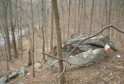
The controls will be standard size markers with the white/orange/blue stripe with control punches. Some checkpoints may be manned. The total number of controls is planned for around 35-40. Placement of the controls will vary as will the point value of each location. Many will be at obvious "beginner friendly" locations such as trail/stream junctions, etc. but there will also be some that are very challenging to locate and will test the abilities of better navigators.
The mountain bike division is an option for solo racers who would rather roll than run/hike. Obviously all of the checkpoints will not be able to be ridden to, but many will. Others will be reasonably close to a trail so bikers may have to dismount and travel off-trail for a short distance on foot. I think in order to do well in this category the mountain bikers will still likely have to do at least some off-bike travel.