Sunday, August 26, 2007

Orienteering at Blue Spruce Park, Indiana, PA

Orienteering by Western Pennsylvania Orienteering Club

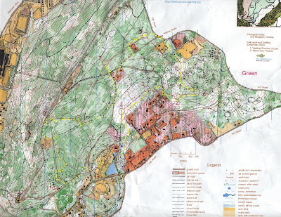
A green course that was more weighted on the navigation aspect.

Some difficulty in finding 3, found a pile of rocks, looked around, then, at 60 meters, saw the control.

Finding 4 was very rogainish. The exact and precise location felt unknown, criss-crossed a bit, there were some dense patches of vegetation.

Finding 5 almost lost it, but then got lucky, saw the stream and from there took a bearing to East and zoomed right into it.

For 6, decided that since I was wearing long pants, and needed a good bushwacking experience, simply barreled downhill, across the paved road, and to the creek. From there, kept on going East, intersecting three foot trails, and then finding a large trail. For some reason, thought I was north of the oil tank, but then, with the compass noticed that the trail was not a South-to-North direction but more SW-to-NE, and realized I was south of the oil tank. So went downhill (SE) to the clearing with the oil well and followed a trail until a powerline, at which, then followed the stream (more like a re-entrant) to the control.

For 7, went right to it using compass.

For 8, wanted to go straght N to the clearing, but apparently veered a bit NE, so corrected, found the clearing, and ran to the stream.

From 8, ran back to the paved road, and went to 9.

For 10, simply followed trail to nearby hilltop.

For 11, tool the big trail to the clearing with the oil well, and then went straight S. Must have felt the thick bush, that while avoiding it, veered a bit to the E, then along the spur, and across the spur to the W, must have descended too much, criss-crossed to the E, saw the two powerline intecting, and decided to go up one powerline pole, and take a compass bearing to W, and found it right away.

For 12, ran along a big trail all the way to the oil tank in the clearing, and from there, walked across the high grass and descended into the woods. What I should have done instead is find the saddle point between the two clearings on the big trail, and go NW in the woods straight to the control. That is the route (inverted) to go from 12 to 13. Found the creek, and followed it to a foot bridge (not a mapped feature), and to the catching feature right after (a stream junction), then realized on the map that the control is not *right* on the creek, and then, 10 meters on the side, saw the control.

For the last control, decided to go straight to it, even if a side of me said to descend down via trail to the paved road, and then try reaching the control from lower altitute. But I am glad I took the path I did, got lucky and zoomed right into it.

The final run of 400 meters to the finish was painful. I am getting old.

Saturday, August 25, 2007

Orienteering at Hinckley Reservation

Drove to Akron with the family and at 10 AM precisely, we walked into the Akron Zoo, got a map, and did a Zoo-O looking for flamingos, primates, lions, and komodo dragons. The zoo is actually a little known gem, with beautiful architecture and well-thought displays. We left at 11:15 because we had to reach the nearby Hinckley Reservation, where the Northeast Ohio Orienteering Club was organizing an orienteering meet.

After a big of Drive-O trying to find the correct road to the boathouse, we got there at 11:48, and quickly got set up for registration. Wife and kids were planning to do the yellow course, while I wanted to do the Orange, and then, Red, just in time before the meet closed.

The day was not oppresively hot, and the park seemed to have a nordic flavor, with some evergreens lining the roads. With the park mostly forested, there were plenty of beech trees, some mossy earth banks, and beautiful meadows with tall grasses and wild flowers.

--
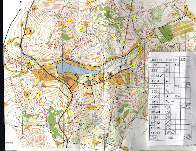
In the Orange course, going from 2 to 3, I opted to go back to the paved road, pass the ravine, and take the wooded area from there. For control 4, lost time trying to find it. Eventually, I found the trail, and realized I overshot it by 80 meters. Going from 4 to 5, chose to take an easy route of following the trail to the clearing, then from the corner of the clearing taking a series of trails. Trying to locate 6 was definitely my biggest mistake. Completely overshot it, and had to back up the stream considerably. Looking for 10, for some reason I was looking for a spur. The clue symbol was "Reentrant", which looks like a spur.

Lost about 2 minutes, while my eyes were focusing on only spurs. Then, found the orange blip on my retina, descended on the reentrant, and said to myself, "this is not a spur". Now that I think about it, the spur symbol has a straight line AND a protuding curve.
Going from 11 to 12, chose to run the clearing. It turned out, it was tall wildflower grass, 2 meters high. It was rough. Not runnable.

In the Red course, I was pretty tired, and said to myself, this is going to be more relaxing. Halfway from 2 to 3, saw the marsh, and felt pretty confident. Then, ended up on a trail and realized I veered to much to the South. From there, went North and saw it right away. On going to 4, recognized some of the terrain in Orange, and in particular that course's control 9. Looking for 6, many people had problems. For some reason, I found the small marsh in the woods 200 meters West of it, and from there, saw the thick vegetation, set compass to NE and just got lucky, the control appeared right in front of me. Lost some time on 7 as I prematurely looked for it on the edges of the hill. 8 was a nice location, seeing these clearings in the middle of the woods is neat. In going from 10 to 11, because I was very tired and just wanted sure trails, chose to go along State Road. I completely missed the trail on the left (there is no trail, the vegetation ate it), and kept going North until i realized what a fool I was. Eventually, after bushwacking some, got to it.

Peculiar error in the clues, is that Orange clue for control 1 has "Cliff", when it should be "Fence". The two symbols are very similar...


Wife's report on Yellow: "finding 4, 5, and 6 was hard. But we found them".

At the end of the meet, we all exchange commentary. It seems that many that did Red had problems finding 6 and somewhat also 3.

It then started raining, and I took the kids to the Ledges trail nearby. We walked a bit, then took shelter under one of the ledges and waited the storm to blow off. We walked along the complomerate rock, slipped through a few of the cracks and slots, and once back to the car, the sun was out in full force. Which then prompted us to go back to the boathouse and rent a couple of paddle boats (ciclyst leg propulsion) for us four and we had one hour of fun in the lake. After that, a quick stop at the spillover area below the dam for a quick swim, and then drive back home.


Thursday, August 16, 2007

Saturday, August 11, 2007

Geocaching in Philadelphia Suburbs

Told 'em sleeping kids at 7:30 AM that I was gonna go geocaching in ten minutes, and slowly, they woke up and paraded down the stairs showless but fully clothed. Still half-awake, we drove to the nearby suburban county park, and in a spot known for a feral cat colony, we found the ammo box.


Friday, August 10, 2007

Mountain Summer Camp in Italy - 30 years later

In a remote area in central italian mountains, once stood a vibrant summer camp managed by the YMCA italian organization. It was located at about 1000 meters of altitude in a farm-house in the area of Palena. The summer camp had about four sessions of two weeks each, during which about 70 kids, ranging in age from 8 to 15, spent time in this rustic mountain setting.


Monday, August 6, 2007

Mount Penn Orienteering

On the return travel from a five-day vacation out on the north-eastern states visiting friends and relatives, we stopped by Reading, Pennsylvania, for a orienteering meet organized by the Delaware Valley Orienteering Club (www.dvoa.org). While Giuseppina and the kids did the yellow course, Sherpes did the green and red course.

The green and red course shared many controls. When doing the green, mistakes where make in control 6 (overmarked with a black-ink 8 for red course), which right after the control, it was my intention to reach the paved road just south of it, but somehow instead ended up on the north side of a private residence. Another mistake was made between controls 6 and 7, where at a 4-street intersection, I went straight when I should have taken the street on my right-side of travel. Another mistake (small one) was right after control 9, should have hugged more closely the water tanks. At finish, time was 55 minutes.

After finishing green, was ready to do another course, and went to see the maps of Brown and Red courses. Expected to see different course from Green, but I realized that Green was just a subset of Red, and Brown just a subset of Green. So signed up for Red, re-utilizing my purchased map for Green, and marked on it the additional controls of the Red course.

Since I already "learned" the terrain while doing the Green course, I expected to do very well on the Red course. Contrary to my expectations, I did very very poorly.

On the approach from control 1 to control 2, instead of bushwacking through the woods as I did when doing the Green course, this time I utilized a trail that took me close to the western edge of some private homes. After finding control 2, I went looking for control 3. I must have spent 25 minutes looking for it, with numerous times getting disoriented. Finally, decided to move East towards the road, and use that as an attack point, and eventually found it. I think my biggest mistake was believing to be on the trail on relief about 80 meters southeast of the control, shown on the map with sloped edges on both sides, when I was actually on the same trail but 150 meters more on southwest, also in relief. I eventually found a control attached to a rootstock (yellow circle), that was probably used for the Orange course. From there, looking at the map for rootstocks in the area, eventually convinced myself that I had to start from an attack point much more northeast than I thought.


On the approach to 5, stayed on trail and used the powerline to guide me. I chose not to shortcut through on a more direct route since the summer vegetation seemed very green and thick, and chose not to risk it. On the approach to 7, missed it by probably 50 meters, then climbed up the hill and criss-crossed the terrain again to finally see it. On the approach to 9, used trail and powerline to easily find it, and from 9 to 10, returned to the powerline, main trail, road, and the big fire road. Then, used the side trail coming from the south (my left on diretion of travel) as a reference to when to leave trail and travel north to easily find it (later, talking to others that did the Red, found out that no one did this route, but instead came from the north. The control was easily visible for those coming from the south, but not for those coming from the north). When going from control 11 to 12, this time hugged the water tanks closely, and found 12 simply by recognizing the rock from when doing Green. At finish, time was 90 minutes.

The terrain on Mount Penn was very rocky, with many small boulders, often covered by ferns and grass. Between controls 2 and 3, the runnability of the terrain was low, and had to tip-toe from rock to rock on many occasions. As I progressed and learned the terrain, I slowly adopted more of a strategy to choose trails rather than bushwacking through woods. I felt my ankles were worth more than a couple of minutes off my finish time. So, for example, from control 8 to 9 on Red, simply looked for the closest trail or path devoid of rocks, and went zooming from there.

Below are maps and clues of Yellow, Green, Red courses.


Coon Cave

On late July, Norm "Norton" Snyder lead a trip to Coon Cave on the Chestnut Ridge near Bolivar, Pennsylvania.

As usual, we met at the commuter parking lot near the intersection of I-376 and South Braddock Ave in Edgewood, and from there, packed three vehicles with four occupants in each and reached the parking area from where to start the hike up the mountain to where the cave entrance is located.

We had three non-adults, Luca, Peer, and Tyler, which kept the group animanted, and other outdoorsy folks that shared interests in running, hiking, mt biking.

At the cave entrance, we met a camp counselor that told us that a group of kids was already in the cave.

In the cave, we crawled and explored side passages, and finally found the mud room. In the mud room, those with artistic talents went on and created mud sculptures, a crocodile, an elephant, a sun dial.

Towards the end of the cave trip, we stopped by the Birth Canal, where we all took turns into crawling through it. As one person commented, with the obesity epidemic, that tight crawl is going to get wider and wider, as more people scraping a millimeter here and there on the passage's walls will make it inevitably wider.

To exit the cave, we took the original entrance, a tight vertical opening.