The trail runs from Greensboro, Pennsylvania on the Monongahela River in the east to the Ohio River in West Virginia. In prehistoric times it was used to obtain supplies of flint from the Flint Ridge area in Ohio and conduct commerce. From the eastern terminus at Milepost 0 on the Monongahela River the trail is generally east-west about 5 to 6 miles north of the Mason Dixon line, passing over 1-79 near the new Kirby Welcome Center. It extends 45 miles westward across Greene County to the border with Marshall County, West Virginia. In Marshall County it extends for an additional 22 miles to the western terminus on the Ohio. The trail follows the divide between watersheds. There are no streams to ford. It is blazed with yellow dots on posts and trees along the trail and on both sides of any road crossing. It can easily be located and entered at any one of these crossings.
Trail guide documents are available upon request; the guides consists of descriptions of significant points of interest along the trail and a series of detailed topographic maps. Information on contacts, access points, and shelters is also included. These guides were originally written in 1988 and was updated in 1999. For additional information, contact: Warrior Trail Association, P O Box 103, Waynesburg, PA 15370-0103.
Reccomended hikes:
1. park right next to the road going over I-79 where the trail crosses over. Hike east for about 11 km and back. Crosses wild sections in state gameland. Hike on sunday when there is no hunting.


2. Park very close to the West Virginia border, and hike west 10 miles and back. Terrain is forested and deeply cragged and sloped. Trail maintains even altitude by staying on the ridge line.


3. Park in Windy Gap church parking lot, then hike east for 5 km, to PA Road 3012 (I would not hike the next 3 km, since they are basically next to a road...)


4. Park in Windy Gap church lot and hike 4 km west and back.


Going West from the PA/WV border, and staying on the ridgeline separating the two water basins


Trip Report


from a newsletter:
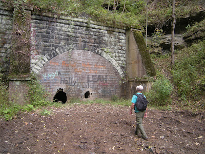
I always wanted to see the 1852 tunnel in the valley below. The tunnel had been blocked closed when abandoned but that kids had knocked a hole into the block. Darn, I didn’t bring a flash light. I easily found the tunnel. It was a fine example of 19th century stone work with some 1909 repairs. I climbed inside. After looking around I realized that yes, there was light at the end of the tunnel. There was a hole at the other end, 1253 feet away. Tempting. After some hesitation I started through. It was pitch black in the middle and I couldn’t see my feet, but I figured that if I kept my left hand on the wall and felt for holes with my feet before stepping forward, I could inch my way to the other side. I made it about half way and I was doing fine. Then the water started. First it covered my boots. That wasn’t too bad. Then it was up to my knees. Cold but not too bad. And by now I was getting close to the end and I really didn’t feel like turning around. Then it was time to take my wallet out of my shorts and put it in my hat. But I was getting really close. By the time I made it to the exit hole the water was up to mid-chest and my legs were tingling. I was ready to get out. Brrr, but what an adventure! I popped out to a sunny day. I drained my boots and wrung out my shorts before eating lunch and heading home. I have thoroughly seen the Welling Tunnel.


No comments:
Post a Comment