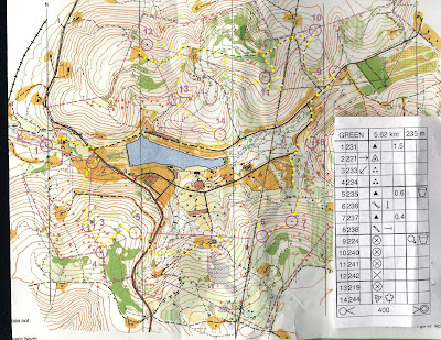
A green course that was more weighted on the navigation aspect.
Some difficulty in finding 3, found a pile of rocks, looked around, then, at 60 meters, saw the control.
Finding 4 was very rogainish. The exact and precise location felt unknown, criss-crossed a bit, there were some dense patches of vegetation.
Finding 5 almost lost it, but then got lucky, saw the stream and from there took a bearing to East and zoomed right into it.
For 6, decided that since I was wearing long pants, and needed a good bushwacking experience, simply barreled downhill, across the paved road, and to the creek. From there, kept on going East, intersecting three foot trails, and then finding a large trail. For some reason, thought I was north of the oil tank, but then, with the compass noticed that the trail was not a South-to-North direction but more SW-to-NE, and realized I was south of the oil tank. So went downhill (SE) to the clearing with the oil well and followed a trail until a powerline, at which, then followed the stream (more like a re-entrant) to the control.
For 7, went right to it using compass.
For 8, wanted to go straght N to the clearing, but apparently veered a bit NE, so corrected, found the clearing, and ran to the stream.
From 8, ran back to the paved road, and went to 9.
For 10, simply followed trail to nearby hilltop.
For 11, tool the big trail to the clearing with the oil well, and then went straight S. Must have felt the thick bush, that while avoiding it, veered a bit to the E, then along the spur, and across the spur to the W, must have descended too much, criss-crossed to the E, saw the two powerline intecting, and decided to go up one powerline pole, and take a compass bearing to W, and found it right away.
For 12, ran along a big trail all the way to the oil tank in the clearing, and from there, walked across the high grass and descended into the woods. What I should have done instead is find the saddle point between the two clearings on the big trail, and go NW in the woods straight to the control. That is the route (inverted) to go from 12 to 13. Found the creek, and followed it to a foot bridge (not a mapped feature), and to the catching feature right after (a stream junction), then realized on the map that the control is not *right* on the creek, and then, 10 meters on the side, saw the control.
For the last control, decided to go straight to it, even if a side of me said to descend down via trail to the paved road, and then try reaching the control from lower altitute. But I am glad I took the path I did, got lucky and zoomed right into it.
The final run of 400 meters to the finish was painful. I am getting old.

No comments:
Post a Comment