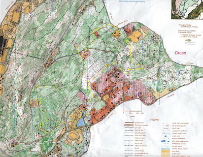
The green and red course shared many controls. When doing the green, mistakes where make in control 6 (overmarked with a black-ink 8 for red course), which right after the control, it was my intention to reach the paved road just south of it, but somehow instead ended up on the north side of a private residence. Another mistake was made between controls 6 and 7, where at a 4-street intersection, I went straight when I should have taken the street on my right-side of travel. Another mistake (small one) was right after control 9, should have hugged more closely the water tanks. At finish, time was 55 minutes.
After finishing green, was ready to do another course, and went to see the maps of Brown and Red courses. Expected to see different course from Green, but I realized that Green was just a subset of Red, and Brown just a subset of Green. So signed up for Red, re-utilizing my purchased map for Green, and marked on it the additional controls of the Red course.
Since I already "learned" the terrain while doing the Green course, I expected to do very well on the Red course. Contrary to my expectations, I did very very poorly.
On the approach from control 1 to control 2, instead of bushwacking through the woods as I did when doing the Green course, this time I utilized a trail that took me close to the western edge of some private homes. After finding control 2, I went looking for control 3. I must have spent 25 minutes looking for it, with numerous times getting disoriented. Finally, decided to move East towards the road, and use that as an attack point, and eventually found it. I think my biggest mistake was believing to be on the trail on relief about 80 meters southeast of the control, shown on the map with sloped edges on both sides, when I was actually on the same trail but 150 meters more on southwest, also in relief. I eventually found a control attached to a rootstock (yellow circle), that was probably used for the Orange course. From there, looking at the map for rootstocks in the area, eventually convinced myself that I had to start from an attack point much more northeast than I thought.

On the approach to 5, stayed on trail and used the powerline to guide me. I chose not to shortcut through on a more direct route since the summer vegetation seemed very green and thick, and chose not to risk it. On the approach to 7, missed it by probably 50 meters, then climbed up the hill and criss-crossed the terrain again to finally see it. On the approach to 9, used trail and powerline to easily find it, and from 9 to 10, returned to the powerline, main trail, road, and the big fire road. Then, used the side trail coming from the south (my left on diretion of travel) as a reference to when to leave trail and travel north to easily find it (later, talking to others that did the Red, found out that no one did this route, but instead came from the north. The control was easily visible for those coming from the south, but not for those coming from the north). When going from control 11 to 12, this time hugged the water tanks closely, and found 12 simply by recognizing the rock from when doing Green. At finish, time was 90 minutes.
The terrain on Mount Penn was very rocky, with many small boulders, often covered by ferns and grass. Between controls 2 and 3, the runnability of the terrain was low, and had to tip-toe from rock to rock on many occasions. As I progressed and learned the terrain, I slowly adopted more of a strategy to choose trails rather than bushwacking through woods. I felt my ankles were worth more than a couple of minutes off my finish time. So, for example, from control 8 to 9 on Red, simply looked for the closest trail or path devoid of rocks, and went zooming from there.
Below are maps and clues of Yellow, Green, Red courses.


No comments:
Post a Comment