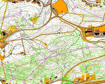
Saturday's Sprint run was on the campus of Lehigh University. We all wore regular running shoes. The course was all downhill. One had to be extra careful on not going over areas that were colored in Olive Green on the map, risking disqualification. That color is usually reserved for manicured flower-beds.
From the start, things went a bit wrong: should have take the lower parking lot (to the north), and ended up losing some seconds by climbing over a guardrail when going from one parking lot to the other. The approach from 1 to 2 was unevent full, just a long pavement run. From 2 to 3, recognized that the control was behind the building, and took a clockwise direction to it. From 3 to 4, went through a passage between buildings, and then a metail stairway from the paved area to the road above, next to a concrete wall.

A long pavement run to control 4. After 4, to 5, debated whether I should backtrack and round the building from the West, but chose a more open approach on to the parking lot, going anti-clockwise, but then, at the corner of the parking lot after siding the retaining wall, saw the olive green on the map and made sure I descended on the road below by running over the white mapped area, woodsy terrain. Then to the other side of the building on a terraced walkway, but lost my bearing a bit, consulted the map, and realized that control 5 was right under me and went for it. For 6, rushing judgement I went to much downhill looking for it and instead should have read the clue sheet and realized it was by the entrance of the building on. The approach to 7 was fast and downhillish, along some grass, always in doubt whether it was Olive Green or not (it was not, thanks !!). Approach to 8 was uneventfull. On the approach to 9, made a mistake by going too much East and not recognizing the end of the building. When I saw the huge building on the South, I started asking questions, and after consulting the map, realized I went too far. On approach to 10, went West and then followed a concrete walkway downhill (NE, then N) to the fountain. There was a patch of greenery that looked manicured that I jumped over, just in case if race officials were looking to see that I walked over manicured grounds, which is grounds for disqualification, but I see now that it is not Olive Green. Hard to tell...

On approach to 11, took a little alley between buildings, recognized another fountain on the East, then another alley between buildings and rounded the building clockwise to find the control. On approach to 12, continued clockwise, saw the fountain again, back to the first alley, and then, at the end of a small paved area, the control. To 13, followed what was familiar and went down that alley again, then through a large paved area, to the chapel side. On to 14, continued around chapel in clockwise direction (should have instead backtracked), got to the main road, could see the finish tent and groups of people greeting finishers, saw the alley going north, went for it, saw a control (it was 15), walked down some steps into a road below, went all around the building looking for 14, but a wall and construction area kept me out the perimeter until I found an alley to the raised platform with the sculpture and control 14. Now, of course I knew where 15 was, went for it, knew the steps going down, went for it, and more steps into a cafe/shopping area with control 16 on the corner. Back the steps towards 17, I could see it but it was on top of a 3 meter wall, ran around the wall and hedge to punch that, and then to 18 and finish.

Monday's Middle distance run was in a wooded area of Hickory Run state park. The controls were difficult to find, and the terrain not easily recognizable.
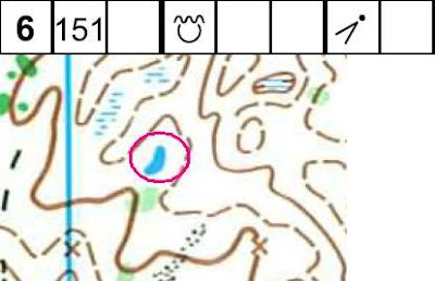
Used the very visible square depression in a clearing as reference, then the two stone walls and then the creek crossing to find 1. On approaching 2, went parallel to the creek going South, then over a spur slightly downhill, recognized the marsh, crossed it going East and found control2. Set the compass to East until finding the second creek crossing and its turn, then set the compass to NE to find 3. On going to 4, went N to find the small body of water, and continuing on its side to find 4. On approach to 5, went W, crossed the creek, then parallelized it and staying on the northern side of the creek, went over the small hilltop to find control 5.

The approach to 6 was the most difficult. Leaving 5, went slightly downhill, found the creek on the West, and parallelized it. The marshy and relatively flat environment made it a bit difficult to recognize the creek junction of a creek coming from the East. Continued going parallel to the creek, until the very distinctive jug-handle turn of the creek. Saw that on the map, and went straight South from there. After pretty much feature-less terrain, very difficult to read, saw a couple of orienteerers running at full speed to the West, and figured they must have found control 6 and were continuing to their next control. Went East a bit until seeing the control. This was hard. Talking to other orienteerers after the event, the more experienced told me that the vegetation boundary on the map just north of the control was the best indicator on the approach, being that the vegetation boundary is, in this terrain, most likely pine trees, and they are very very distinct at a far distance, even in a deciduous woodland, so they just ran straight to where they saw the pine trees and easily found the control from there.

On the approach to 7, after all the difficulties in navigating to 6, chose a very conservative approach, and used the very visible terrain features of the creeks north of control 6. Noticed specially the jug-handle turn of the creek NW of control 6. Then continued north until hitting the stone wall, and then follow the stonewall on an westerly direction. Notice that just north of the stone wall there is a line of stony ground, and for a moment it looked like point where the stone wall was turning to the north, but no, I noticed the stone wall continued, so for a moment, I was caught in a dilemma on where to go.

Monday's Long run was on the South Mountain area just south of Lehigh University campus. At one point, came right under the Bethlehem Star. Missed 11 but was able to backtrack and find it (noticed from the result that someone else also missed it). My biggest question is: what is the best route from 6 to 7. Someone ahead of me went downhill and took it from there. I preferred staying uphill.


Middle Distance White

Middle Distance Yellow

Middle Distance Brown


Middle Distance Orange


Middle Distance Green Women

Middle Distance Green Men

Middle Distance Red Women


Middle Distance Red Men


Middle Distance Blue


Long Distance White

Long Distance Yellow

Long Distance Brown

Long Distance Orange


Long Distance Green Women


Long Distance Green Men


Long Distance Red Women


Long Distance Red Men


Long Distance Blue


by course
Day 1
Day 2
Day 3
--
by class
day 1
day 2
Day 3
---
Route Gadget
Day 1
Day 2
Day 3
Who is that bear in the woods ? the art of stealth photo in orienteering...

Focused

Route reading

Dynamic photo showing both shoes off the ground

Depression in Hickory Run


Boulder in Hickory Run


Pond in Hickory Run


Thick in Hickory Run

